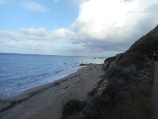
€240,000above village land medianKalamitsi
Land in Kalamitsi, 6 000 m2
6 000 m² land
50 m to the coast · about 35 min to Lefkada Town centre
- Price / m² land
- €40
- Position
- Exact location
Kalamitsi, Lefkada, Ionian Islands, Greece


10 items, shown from DNK Estate.
Data confidence and methodology
Median comparison uses the 353 records that carry an asking price, out of 408 listings from DNK Estate, Lefkada Real Estate and Pandev Real Estate, last read at their sources between 20 September 2026 and 23 September 2026.
Drive times are a routing engine's estimate on the mapped road network, with no traffic and no season in them, and they are not a timetable: ferry sailings and flight schedules are not published here. Full methodology.
This plot in Kalamitsi, Lefkada, has 6 500 m² of land. No asking price is published for it, so it is listed on application.
Figures as published by DNK Estate.
How these are worded
The town plan is the development plan a Greek municipality draws for a settlement. Plots inside it and plots outside it fall under different building rules. The zoning area is a separate designation and a plot can be outside one and inside the other, which is why they are listed as two statements rather than one. Which rules apply to a particular plot is a question for the seller's engineer or the local planning office, and this page does not answer it.
Each one is the source's own tag, restated in a fixed IsleScout wording so that two listings from different agencies can be read side by side. A tag we have no wording for is left out rather than repeated as the source wrote it.
Stated by DNK Estate. IsleScout has not checked any of it, and nothing here says what may be built on the plot or what a permit would allow.
Tick a kind to draw it on the map, counted within 2 km in a straight line, which can be a longer walk.
Mapped position, exact precision
This record stores an exact coordinate, so the marker is the position itself. The rings are 1 km and 2 km from it, drawn to give the map a sense of scale: the places counted below are the ones inside the outer ring.
How the terrain and the drive times are measured
Elevation and slope: EU-DEM 25 m (Copernicus), read 8 August 2026. A 25 m grid describes the hillside, never the plot: it does not know about a terrace cut into the slope or a retaining wall. Slope is the gradient across a 30 m ring and is called level below 5%, gentle below 10%, moderate below 20%, and steep above it.
Ground to the shore is a straight sight line from here to the nearest coastline over that same grid. It says whether the land falls the whole way, which is what a sea view needs and nowhere near all it needs. It is not a view from a window, and no window, tree, or neighbouring building is in it.
Drive times: routing on the OpenStreetMap road network, licensed ODbL, read 8 August 2026. The routing engine's own estimate on the mapped road network, with no traffic, no season, and no queue at the port in it, rounded to five minutes. Ferry sailings and flight schedules are not published here.
| Measure | Value |
|---|---|
| Elevationon a 25 m elevation grid | 17 m |
| Slopesteep | 28% |
| Distance to the coaststraight line to the nearest shoreline | 50 m |
| Drive to AirportAktion National Airport | about 65 min |
| Drive to Lefkada Townthe town centre | about 35 min |
| Drive to Ferry portNydri Port | about 45 min |
| Drive to HospitalLefkada Hospital | about 35 min |
How these figures are measured
the national broadband map (XEMD), Ministry of Digital Governance, read 20 August 2026. A band is the fastest download providers say they can supply: not a measured speed, and not a promise that an order will be accepted at one house. Fixed and mobile are two separate readings, so an area can hold one and not the other.
Fibre is counted as reaching a village when the registry lists an address it can connect within 400 m of this position. It says fibre reached the village, never this building, and an order still has to be accepted. Satellite covers all of Greece at satellite prices and is not in this reading.
Providers report mobile 300 to 1000 Mbit/s here, and fibre has not reached this village.
| Measure | Value |
|---|---|
| Fixed lineno reading here, which is not the same as no coverage | Not reported |
| Mobilefastest download mobile providers report for this area | 300 to 1000 Mbit/s |
| Fibre | Not in this village |
How these distances are measured
OpenStreetMap data, read 8 August 2026, licensed ODbL. The everyday kinds are walking routes on the mapped footpath and road network, rounded to five minutes, and each row says so. A path nobody has mapped is a path the router cannot use, so a walk errs long rather than short, and it describes a route rather than a pavement: it says nothing about lighting, traffic, or whether anybody would want to walk it. It is a flat-ground pace, because the router does not read the gradient: on a slope it describes the way down and the way back is the longer half, and the elevation beside the coast row is what that walk climbs. The coast and the remaining access rows are straight lines and say that instead. The drive times above are routed separately and say so. Walking routes: Valhalla on the OpenStreetMap footpath network, read 17 August 2026, licensed ODbL. The nearest of each kind is given at any distance, so a property with nothing walkable still says how far away it is; the count beside it is only of what falls within 2 km. Coverage varies by area, so a place that is not listed is one that is not recorded in OpenStreetMap, which is not the same as one that is not there. A bus stop is a location, not a timetable. The hospital row is the one with an emergency department, not every building tagged as a hospital: village surgeries are counted under doctors and clinics. The ferry port means a port with scheduled vehicle sailings, not every landing tagged as a ferry terminal: a small boat to a nearby islet is not a way off the island and is left out. Lefkada is reached from the mainland by road across the Agia Mavra causeway, so no port here sails to it and the row is the port with scheduled vehicle sailings to the neighbouring islands. The drive time is to Aktion, on the mainland, for the same reason: the island has no airfield of its own. The main town is the island's own, which here is Lefkada Town.
| Place | Nearest |
|---|---|
| Everyday serviceskinds within a 2 km walk | 1 of 8 |
| Coastnearest shoreline, from 17 m above sea level | 50 m |
| Marina or mooringNikiana Marina | 10.8 km |
| BeachGaidaros, about 5 min walk | 400 m |
| SupermarketJoin In, about 1 h 5 min walk | 4.5 km |
| Pharmacyabout 1 h 5 min walk | 4.5 km |
| Doctor or clinicMy Doctor medical services Lefkada, about 3 h 50 min walk | 16.1 km |
| SchoolGymnasio & L.T. Karyas, about 3 h 40 min walk | 13.4 km |
| Bus stopAgios Nikitas, about 1 h 5 min walk | 4.4 km |
| BankEurobank, about 3 h 50 min walk | 16.2 km |
| Fuel stationREVOIL, about 3 h 35 min walk | 14.9 km |
Where these questions come from
The subjects come from this record's own empty fields. The phrasing is generated, and it can assume a detail the listing has not stated, so treat these as prompts for the source rather than as facts about the property.
5 fields our record does not hold for this property, turned into questions you can put straight to the source.
What the figures on these cards mean
Price per m² on a card is an IsleScout calculation, that record's asking price divided by the floor or land area recorded for it, never a rate for the locality.
Distance to the coast is a straight line to the nearest shoreline, not a walk, and the time to Lefkada Town is a routing estimate with no traffic in it, rounded to five minutes. Both are measured the same way as the tables above, from the record's mapped position or from its village centre where the position is only approximate.
6 000 m² land
50 m to the coast · about 35 min to Lefkada Town centre
1 820 m² land
1.2 km to the coast · about 20 min to Lefkada Town centre · ground falls to the shore
